


…WINTER WEATHER ADVISORY REMAINS IN EFFECT UNTIL NOON CST SATURDAY…
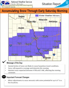
Total snow accumulations of 2 to 5 inches with localized areas of 6 to 7 inches are expected across portions of east central, northeast and southeast Nebraska and southwest Iowa.
Plan on slippery road conditions. The hazardous conditions could impact the evening commute.
Slow down and use caution while traveling. The latest road conditions for the state you are calling from can be obtained by calling 5 1 1.
Snow has begun to overspread the area and should become widespread through the afternoon. Snow is expected to continue through Saturday morning with the greatest snow accumulation potential expected from a line from Columbus to Tekamah south to a line from Crete to Red Oak, Iowa.
Highest snow rates are expected from 3 PM Friday to 3 AM Saturday, so the Friday evening commute could be hazardous. Snowfall rates of 0.5 inches an hour are possible and will lead to limited visibility for any roadways.
A widespread area of 2-5 inches is expected, with some areas receiving 6 to 7 inches by the end of the event.
Saturday through Thursday Snow is expected to taper off Saturday morning. There is a very slight chance of snow Monday night into Tuesday.


