


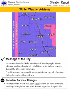
A Winter Weather Advisory is in effect from midnight until 6 AM Wednesday. Snow will develop tonight and continue into Tuesday evening before diminishing.
Some light freezing rain could mix with the snow before ending. Peak snow intensities are expected from mid morning on Tuesday into Tuesday afternoon, making the afternoon or evening commute difficult.
Total snow accumulations will range from three to six inches. Up to a tenth of an inch of flat ice accumulation is also possible.
The National Weather Service Official Forecast:
National Weather Service Omaha/Valley NE 334 AM CST Mon Dec 28 2020
NEZ011-012-016>018-030>033-042>044-050-051-065-066-281800- /O.UPG.KOAX.WS.A.0002.201229T0600Z-201230T1500Z/ /O.NEW.KOAX.WW.Y.0021.201229T0600Z-201230T1200Z/ Knox-Cedar-Antelope-Pierce-Wayne-Boone-Madison-Stanton-Cuming- Platte-Colfax-Dodge-Butler-Saunders-Seward-Lancaster- Including the cities of Creighton, Bloomfield, Crofton, Wausa, Verdigre, Niobrara, Hartington, Laurel, Randolph, Coleridge, Neligh, Elgin, Pierce, Plainview, Osmond, Wayne, Albion, St. Edward, Norfolk, Stanton, West Point, Wisner, Columbus, Schuyler, Fremont, David City, Wahoo, Ashland, Yutan, Seward, Milford, and Lincoln 334 AM CST Mon Dec 28 2020
…WINTER WEATHER ADVISORY IN EFFECT FROM MIDNIGHT TONIGHT TO 6 AM CST WEDNESDAY…
*WHAT…Mixed precipitation expected. Total snow accumulations of 3 to 6 inches and ice accumulations of around one tenth of an inch.
* WHERE…Portions of east central, northeast and southeast Nebraska.
* WHEN…From midnight tonight to 6 AM CST Wednesday. * IMPACTS…Plan on slippery road conditions. The hazardous conditions will especially impact the Tuesday evening commute.
PRECAUTIONARY/PREPAREDNESS ACTIONS… Slow down and use caution while traveling. The latest road conditions for the state you are calling from can be obtained by calling 5 1 1.


