


…WINTER STORM WARNING REMAINS IN EFFECT FROM 6 AM MONDAY TO 3 AM CST TUESDAY…
The National Weather Service held a ‘partners webinar’ with media and public safety personnel across the warning area Sunday afternoon and indicated this could be a storm of historic proportions.
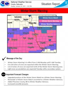
Heavy snow expected. Total snow accumulations of 8 to 14 inches across portions of east central and southeast Nebraska and southwest Iowa.
Travel could be very difficult. Areas of blowing snow will significantly reduce visibility. The hazardous conditions will affect the morning or evening commute.
Northeast wind 15 to 25 mph with gusts as high as 30 to 35 mph.
If you must travel, keep an extra flashlight, food, and water in your vehicle in case of an emergency. Travel may eventually become impossible. The latest road conditions for the state you are calling from can be obtained by calling 5 1 1.
ADDITIONAL DETAILS: SEE MAPS AND DETAILS AT END OF STORY.
Areas of snow will develop after midnight tonight across southeast Nebraska and then spread northward toward Interstate 80 by 6 am Monday morning. The snow then overspreads much of the area continues into Monday night.
A winter storm warning remains in effect along and south of a line from David City Nebraska to Fremont Nebraska to Harlan Iowa.
A winter weather advisory will be in effect for other portions of northeast Nebraska and northwest Iowa.
Snowfall amounts in the winter storm area could range from 6 to 15 inches. A widespread area of 9 to 12 inches are forecast for much of the area along and south of Interstate 80. The highest amounts of 15 inches are forecast centered around Nebraska City. Snow amounts in extreme northeast Nebraska near the South Dakota border may not measure much if any at all.
Northeasterly winds will blow at 15 to 25 mph during the event, with gusts as high as 30 to 35 mph at times. This will create areas of blowing snow during the day Monday. Snowfall rates could range 1-2 inches per hour for southeast Nebraska Monday afternoon.
Travel will be significantly impacted. Travel may eventually become impossible in some locations the receive a foot or more of snow. .
Tuesday through Sunday There is potential for an additional 1 to 2 inches of snow with another system from late Tuesday afternoon through early Wednesday morning.


