


…WINTER STORM WARNING NOW IN EFFECT UNTIL 9 AM CST TUESDAY…
Heavy snow with additional snow accumulations of 4 to 6 inches across portions of east central and southeast Nebraska and southwest Iowa.
Plan on slippery road conditions. Areas of blowing snow could significantly reduce visibility. The hazardous conditions will affect the evening and commute.
If you must travel, keep an extra flashlight, food, and water in your vehicle in case of an emergency. The latest road conditions for the state you are calling from can be obtained by calling 5 1 1.
***
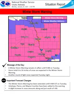
A large winter storm continues to move across the region. Snow will continue through the afternoon and evening for much of the area. A winter storm warning is in effect for most of the area.
A winter weather advisory is in effect in counties near the Nebraska, South Dakota border. Snowfall amounts in the winter storm area will range from 6 to 16 inches.
A widespread area of 9 to 12 inches are forecast for much of the area around Interstate 80. Isolated higher amounts up toward 18 inches are possible, especially around and just south of I-80.
Northeasterly winds will blow at 15 to 25 mph, with gusts as high as 30 to 35 mph at times. This will create areas of blowing snow during the day Monday. Snowfall rates should range 1-2 inches per hour in areas of the heaviest snowfall. heavy, wet snow combined with strong winds could lead to power outages.
Travel will be difficult, if not impossible for the evening commute. Snow will accumulate quickly and roads continue to rapidly become snow covered.
Snow from this system will linger into Tuesday morning and should come to an end by 6 AM. Additional snow is possible Tuesday night as another system moves into the area. Amounts from this 2nd system should be 1 inch or less.


