


Patchy, dense fog will linger into mid morning before dissipating. Areas of dense fog may form again tonight into Wednesday morning. Ice has been moving down the Platte River across eastern Nebraska, leading to fluctuating water levels, especially near Fremont from the State Lakes to Big Island.
If you have interests along this river, monitor levels closely as they may fluctuate quickly due to ice action.
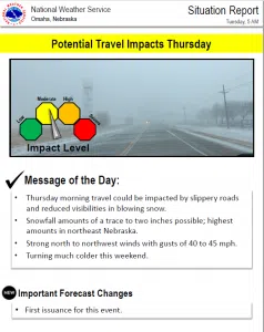
A strong cold front will plunge through the region Wednesday night and Thursday morning, bringing much colder temperatures. Snow accumulations from 1 to 2 inches are possible, mainly from early Thursday morning to early Thursday afternoon.
The snow will coincide with north or northwest winds gusting to 40 to 45 mph. Travel may be affected due to reduced visibilities and slippery roads.
High temperatures for the weekend will likely only reach the the single digits or teens, with lows in the single digits above and below zero.
Wind chills Sunday morning could reach 15 to 25 below zero.


