


…WINTER WEATHER ADVISORY IN EFFECT FROM 2 AM TO NOON CST THURSDAY…
Mixed precipitation is expected across portions of east central, northeast and southeast Nebraska and southwest and west central Iowa. Total snow accumulations of up to two inches and ice accumulations of a light glaze. Winds gusting as high as 40 mph.
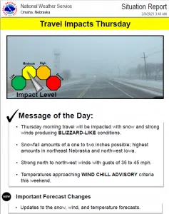
Plan on slippery road conditions. Falling and blowing snow could significantly reduce visibility. The hazardous conditions will affect the morning commute.
Slow down and use caution while traveling. The latest road conditions for the state you are calling from can be obtained by calling 5 1 1.
This Advisory is for the following Counties: Monona-Harrison-Shelby-Pottawattamie-Mills-Montgomery-Fremont- Page-Thurston-Cuming-Burt-Colfax-Dodge-Washington-Butler-Saunders- Douglas-Sarpy-Seward-Lancaster-Cass-Otoe-Saline-Johnson-Nemaha
Including the cities of: Onawa, Mapleton, Missouri Valley, Woodbine, Logan, Dunlap, Harlan, Council Bluffs, Glenwood, Red Oak, Sidney, Hamburg, Tabor, Farragut, Clarinda, Shenandoah, Pender, Macy, Walthill, Winnebago, West Point, Wisner, Tekamah, Oakland, Lyons, Decatur, Schuyler, Fremont, Blair, David City, Wahoo, Ashland, Yutan, Omaha, Bellevue, Papillion, La Vista, Seward, Milford, Lincoln, Plattsmouth, Nebraska City, Crete, Wilber, Tecumseh, Sterling, and Auburn
Additional Information:
A cold front will push through the region tonight and Thursday morning with strong winds, light snow, and much colder temperatures expected behind it.
Highest snowfall amounts of one to three inches are expected along and north of I-80. The precipitation may begin as light rain or a wintry mix before transitioning to all snow.
Reduced visibilities in falling and blowing snow and slippery roads will result in hazardous travel conditions for the Thursday morning commute, and a winter weather advisory has been posted. .
Friday through Tuesday: Very cold temperatures are forecast this weekend into early next week. Daytime highs will only reach the single digits or teens with lows in the single digits below zero. Wind chills on Sunday, Monday, and Tuesday mornings could reach 10 to 20 below zero.


