


Today and Tonight: Dangerously cold wind chills are expected Friday morning, with values bottoming out at -20 to -30 degrees. A Windchill Advisory has been issued for Friday morning. Another round of snow is possible Friday into early Saturday morning. Total accumulations could range from 1 to 3 inches. The Friday evening commute will be affected.
Saturday through Tuesday: Overnight wind chills will continue to be hazardous through next Tuesday. Wind chill indices will range generally from 20 to 25 below Saturday morning, and could drop to 25 to 40 below from Sunday through Tuesday. Additional windchill products will be needed for the weekend into next week.
And yet another round of additional light snow will be possible along and south of Interstate 80 Sunday into Monday with another half inch to 2 inches.
DETAILS:
…WIND CHILL ADVISORY REMAINS IN EFFECT UNTIL NOON CST TODAY…
…WINTER WEATHER ADVISORY REMAINS IN EFFECT FROM 9 AM THIS MORNING TO 6 AM CST SATURDAY…
…WIND CHILL ADVISORY IN EFFECT FROM MIDNIGHT TONIGHT TO NOON CST SATURDAY…
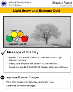
For the first Wind Chill Advisory, very cold wind chills. Wind chills as low as 25 below zero.
For the Winter Weather Advisory, snow expected. Total snow accumulations of 1 to 3 inches.
For the second Wind Chill Advisory, very cold wind chills expected. Wind chills as low as 20 below zero.
Plan on slippery road conditions. The hazardous conditions could affect the morning or evening commute. The cold wind chills could cause frostbite on exposed skin in as little as 30 minutes.
Use caution while traveling outside. Wear appropriate clothing, a hat, and gloves. Slow down and use caution while traveling. The latest road conditions for the state you are calling from can be obtained by calling 5 1 1.


