


More snow and hazardous cold weather is on the way. The National Weather Service reports:
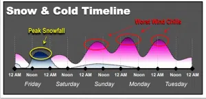
• Another 1 to 5 inches of snow possible today through Saturday morning.
• Colder temperature set in over the weekend
• Winds chill values may plummet to dangerous levels, 20 to 40 degrees below zero at times
The coldest wind chills have shifted toward Sunday, Monday and Tuesday of next week. The actual temperature will range from -20 to 5 degrees. Wind chills will fall to 20 to 40 below zero at times.
Eastern Nebraska and parts of southwest Iowa could receive another 1 to 5 inches of snow through Saturday Those totals may vary.

There is an increase risk of frostbite or hypothermia, especially for any stranded travelers. There is also a chance of slippery road conditions, especially Friday afternoon into Friday night.
The National Weather Service also reminds pet owners there is an increased risk of frostbite and hypothermia for animals.