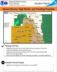
…HIGH WIND WARNING IN EFFECT FROM 3 PM THIS AFTERNOON TO 4 AM CDT WEDNESDAY…
North winds 20 to 30 mph with gusts up to 60 mph are expected across portions of east-central, northeast and southeast Nebraska.
Damaging winds will blow down trees and power lines. Widespread power outages are expected. Travel will be difficult especially for high profile vehicles.
People should avoid being outside in forested areas and around trees and branches. If possible, remain in the lower levels of your home during the windstorm, and avoid windows. Use caution if you must drive.
…FLASH FLOOD WATCH REMAINS IN EFFECT FROM 4 PM THIS AFTERNOON THROUGH 7 AM WEDNESDAY MORNING…
The Flash Flood Watch continues for a portion of southeast Nebraska, including the following areas, Cass, Gage, Jefferson, Johnson, Lancaster, Otoe, Pawnee, Saline, and Seward.
Thunderstorms will bring heavy rain. Rainfall rates greater than 1 inch per hour are expected at times. Some areas within the watch will receive 2 to 4 inches of total rainfall which may lead to flash flooding.
A Flash Flood Watch means that conditions may develop that lead to flash flooding. Flash flooding is a very dangerous situation. You should monitor later forecasts and be prepared to take action should Flash Flood Warnings be issued.